GPS tracking systems help monitor speeding and harsh driving behaviors using satellite signals and accelerometers. These devices calculate speed, detect sudden movements, and provide real-time alerts to improve safety and reduce costs for fleets. Here’s how they work:
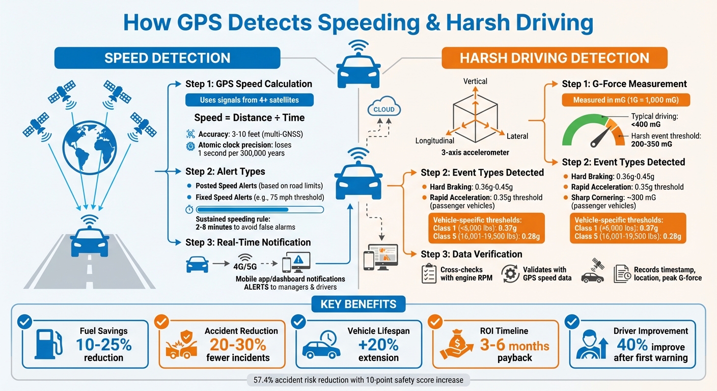
- Speed Detection: GPS calculates speed by dividing distance traveled by time. Devices use data from multiple satellites for accuracy, even in challenging areas like urban environments.
- Harsh Driving: Built-in accelerometers measure G-forces to flag sudden braking, rapid acceleration, or sharp turns. Thresholds can be customized to suit different vehicle types.
- Real-Time Alerts: Managers receive instant notifications for speeding or harsh events via apps or dashboards, enabling timely corrective actions.
- Benefits: Monitoring driver behavior can cut fuel costs by up to 25%, reduce accidents by 20–30%, and extend vehicle lifespans by 20%.
These systems also generate detailed reports, driver scorecards, and trend analyses, helping fleets improve safety and efficiency while lowering expenses.
How GPS Tracking Systems Detect Speeding and Harsh Driving Behavior
How GPS Detects Speeding
Speed Calculation Using GPS
GPS determines speed by dividing the distance traveled by the time it took to cover that distance. The device relies on signals from at least four satellites, measuring the time delay of these signals to pinpoint its position and calculate speed, elevation, and direction of travel.
"As GPS devices move, the radius (distance to the satellite) changes. When the radius changes, new spheres are produced, giving us a new position. We can use that data… to determine velocity." – Geotab Team
The accuracy of these calculations depends on atomic clocks inside the satellites, which are so precise they lose only one second every 300,000 years. This precision is crucial since GPS signals travel at the speed of light. Once the speed is calculated, the tracking device combines this information with ignition status and diagnostics, transmitting it through 4G or 5G networks to a cloud-based dashboard.
In areas with tall buildings – commonly referred to as "urban canyons" – accuracy can be affected. To counter this, fleet managers should opt for trackers that work with multiple satellite systems like Galileo or GLONASS, alongside standard GPS. This combination, known as a multi-GNSS approach, improves accuracy from 16–33 feet to as close as 3–10 feet. These precise calculations allow for setting accurate speed alert thresholds.
Setting Speed Limits for Alerts
Fleet managers can set up speed thresholds using the alerts menu in the tracking platform. Typically, there are two types of speeding alerts:
- Posted Speed Alerts: Triggered when a vehicle exceeds the legal speed limit of the road, based on third-party map data from providers like HERE.COM.
- Fixed Speeding Alerts: Activated when a vehicle surpasses a specific speed, such as 75 mph, regardless of the local road limit.
To avoid false alarms caused by brief speed spikes, managers can implement a sustained speeding rule. This requires multiple consecutive data points (over 2 to 8 minutes) to exceed the limit before flagging a violation.
However, map-based speed limits might not account for temporary changes, like construction zones. It’s essential to verify all details before acting on alerts. For optimal results, set GPS update intervals between 15 seconds and 1 minute. While longer intervals save battery life, they may miss brief speeding incidents. Once set, the device immediately reports violations in real time.
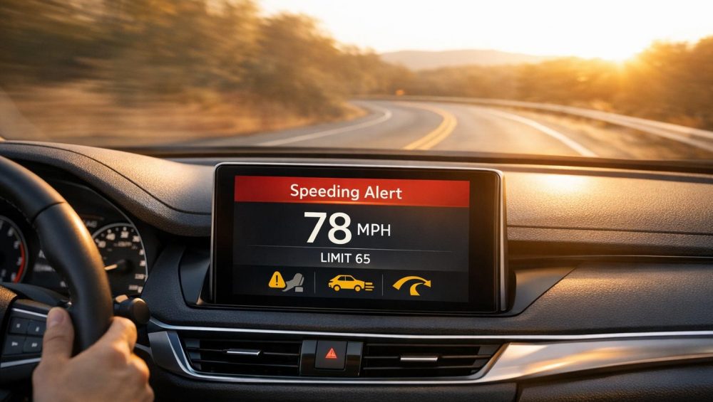
Real-Time Speeding Alerts
With precise speed calculations and preset thresholds, the tracker instantly flags any speeding incidents. When a vehicle exceeds the set limit, the tracker sends the data through its cellular connection to a cloud server. Managers receive notifications via a mobile app or dashboard. Some systems even send automated messages directly to drivers, encouraging them to adjust their behavior immediately.
This instant feedback allows managers to focus on coaching drivers proactively rather than relying solely on disciplinary actions. The data collected can also be used to create driver scorecards and risk reports, helping identify unsafe habits and reward good driving. These insights help protect your fleet from risks and operational inefficiencies. Studies show that monitoring speed can lower fuel costs by 10% to 25%, and nearly half of users report fewer accidents as a result.
GPS Tracking to Improve Fleet Safety
How GPS Identifies Harsh Driving Events
GPS systems do more than monitor speed – they also capture specific driving behaviors by detecting harsh events.
Detecting Harsh Acceleration and Braking
GPS trackers use built-in accelerometers to identify harsh driving patterns. These sensors measure G-forces across three axes: longitudinal, lateral, and vertical. Force is recorded in mG (1G equals 1,000 mG). When a driver accelerates rapidly or brakes suddenly, the longitudinal axis captures the abrupt force changes. If these forces exceed a set threshold – usually between 200 and 350 mG – the system flags it as a harsh event. For context, typical driving rarely exceeds 400 mG.
"If a vehicle reported high forward acceleration, increased RPM and an increasing road speed during a speeding event, it is virtually impossible that the speeding event was incorrect." – Alex Sukhov, Embedded Systems Engineer, Geotab
Modern GPS systems enhance accuracy by pairing accelerometer data with GPS speed and engine diagnostics from the vehicle’s CAN bus. This helps confirm both the severity and circumstances of each event. However, proper installation is key. Devices need to be securely mounted using brackets or high-bond tape; a loose tracker can produce inaccurate readings if it shifts or gets bumped. Lateral forces, which occur during sharp turns, also provide critical insights into harsh cornering.
Identifying Harsh Cornering
Lateral G-force monitoring comes into play when a vehicle takes a sharp turn. If the turn is too aggressive for the vehicle’s weight and center of gravity, the system detects high forces on the left/right axis. For passenger vehicles, harsh cornering typically registers around 300 mG. Fleet managers can adjust these thresholds to suit different vehicle types. For instance, a sedan may tolerate higher G-forces compared to a fully loaded semi-truck. Heavier vehicles require lower thresholds: a Class 5 truck (16,001–19,500 lbs) might use around 0.28g, while a smaller Class 1 vehicle (<6,000 lbs) can handle approximately 0.37g.
Event Logging and Data Analysis
When a harsh event occurs, the GPS tracker records key details like the timestamp, location, and peak G-force. This information feeds into driver behavior reports, helping fleets assess risks and address disputes. Many fleets recover their investment in these systems within 6 to 12 months, thanks to fewer accidents and improved fuel efficiency.
sbb-itb-4827db2
Setting Up Alerts and Notifications
GPS platforms give fleet managers the ability to set up alerts for specific events like speeding or harsh acceleration for selected vehicles or driver groups. You can define parameters such as speed limits or G-force thresholds and even set a duration (like 30–60 seconds) to filter out brief spikes caused by legitimate maneuvers. From there, you can customize thresholds and geofences to fine-tune how and when notifications are triggered.
Customizing Thresholds and Geofences
Once you’ve identified events like speeding or harsh driving, you can adjust thresholds and use geofences for greater precision. For example, you can set fixed speed limits (e.g., 75 mph) or configure alerts to trigger when a driver exceeds the posted speed limit by 10 mph. Similarly, harsh driving thresholds can be tailored to your fleet’s safety standards, such as 0.45g for braking or 0.35g for acceleration.
Geofences add another layer of control, allowing you to restrict alerts to specific zones, like construction sites or school areas. These platforms can manage thousands of geofences, monitoring vehicle entry and exit in real time. To avoid overwhelming managers with repetitive alerts, you can configure a "repeat delay" (e.g., a five-minute interval) to prevent notifications from triggering multiple times when a vehicle crosses the same boundary.
Real-Time Notifications
Alerts can be sent through various channels, including email, SMS, push notifications via fleet apps, Slack integrations, or webhooks for server-side actions. Many systems also provide in-cab feedback, such as buzzers or app-based alerts, to immediately notify drivers of violations. To make alerts more noticeable, managers can encourage drivers to assign a unique SMS tone to the tracking system’s number, ensuring violations are recognized without needing to check their devices.
Real-time notifications can drive significant improvements in fleet behavior. For instance, the City of Fort Lauderdale utilized idling alerts to cut fleet idling by 20% in 2025. Critical alerts can be directed to immediate responders, while non-urgent data can be included in scheduled reports. These real-time notifications also integrate seamlessly with driver behavior reports, enabling proactive fleet management.
Using GPS Data for Insights and Reporting
Once speeding and harsh driving events are flagged, GPS data gets analyzed further to uncover long-term trends in driver behavior. This builds on real-time alerts, offering fleets a way to improve driver habits over time. GPS tracking platforms take raw data and turn it into actionable reports, highlighting patterns and potential safety risks. A key feature of these platforms is Driver Scorecards, which use weighted scoring systems (like A–F grades or numeric scales) based on safety-related events such as hard braking, rapid acceleration, and speeding. For example, speeding often makes up 40% of the total score, while hard braking accounts for 20%, emphasizing behaviors that carry the most risk.
Driver Behavior Reports
The most effective reports don’t just tally up violations – they provide context. Metrics like "violations per 100 miles" ensure fairness by normalizing data, so drivers covering more miles aren’t unfairly penalized compared to those with lighter schedules. Tools for trend analysis can show whether a driver’s behavior is getting better or worse over time. Features like Leaderboards spotlight the top and bottom 10 performers, helping managers focus coaching where it’s needed most.
Studies reveal that 40% of drivers improve their behavior after receiving their first safety warning, and a 10-point increase in a safety score can cut accident risk by 57.4%. Advanced systems even factor in contextual details – like weather conditions or time of day – to better evaluate the actual risk tied to specific driving events. For instance, the chance of preventable accidents rises from 20.1% with one hard braking event per 100 miles to 44.1% with two events. These insights integrate seamlessly into the Piritiz platform, offering a complete solution for managing fleet safety.
Integration with Piritiz Tracking Devices
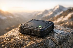
Piritiz Tracking Devices provide 24/7 access to GPS data through a user-friendly mobile app, allowing managers to monitor vehicle locations, statuses, and driver behaviors in real time. Equipped with diagnostic sensors and accelerometers, these devices detect actions like hard braking, rapid acceleration, and sharp turns. The collected data is automatically processed into insights, such as driver scorecards and performance trends, eliminating the need for manual data entry or complicated setups.
Managers can also customize alerts through the Piritiz app to match their safety standards. For example, thresholds for hard turns can be set at 0.35g, while hard braking can be set at 0.36g. The platform’s automated reporting system uses these thresholds to generate weighted scores, making it easier to identify high-risk drivers who need immediate attention. With features like a waterproof, wireless design and a battery life of up to 5 years, Piritiz devices work reliably across various vehicle types – including cars, RVs, trailers, and fleet vehicles – ensuring consistent data collection under all conditions.
Conclusion
GPS tracking systems excel at identifying speeding and harsh driving through a combination of advanced sensors. By leveraging GPS signals, these systems pinpoint vehicle speed and location with an impressive accuracy of 3–5 meters. Simultaneously, 3-axis accelerometers measure G-forces to detect behaviors like hard braking, rapid acceleration, and sharp turns. To ensure reliability, modern setups cross-check these events with engine RPM data, minimizing false alerts.
"Over time, dangerous driving behavior can be identified with a high degree of accuracy."
– Alex Sukhov, Embedded Systems Engineer, Geotab
This precise monitoring capability leads to noticeable operational improvements. Many fleets report fuel savings of 15–25% and a 10–20% reduction in overtime costs thanks to better routing and idle management. Additionally, businesses often see a return on investment within just 3 to 6 months. By identifying high-risk drivers and implementing targeted coaching, companies can reduce accidents, cut down on insurance costs, and protect their assets with tools like geofencing and real-time alerts.
Piritiz Tracking Devices make adopting these advancements straightforward. Their battery-powered trackers, built to last up to 5 years, feature a waterproof, wireless design suitable for cars, RVs, trailers, and fleet vehicles. The accompanying mobile app provides 24/7 driver scorecards, customizable thresholds, and automated reports, turning raw data into meaningful insights. With plans starting at just $7 per month and no contracts or hidden fees, Piritiz offers a cost-effective solution with a strong return on investment.
Whether you’re overseeing a commercial fleet or safeguarding personal vehicles, GPS tracking shifts driver monitoring from a reactive process to a proactive strategy. This seamless approach enhances fleet safety and efficiency while providing full visibility into your assets. Learn more about how Piritiz Tracking Devices can help you reduce costs, improve safety, and gain complete control over your vehicles and equipment.
FAQs
How does GPS stay accurate in cities with tall buildings and obstacles?
GPS stays reliable in urban areas by leveraging signals from several satellites and incorporating advanced tech to tackle issues like signal blockages and reflections caused by tall buildings and dense structures. While GPS accuracy in open areas is usually within 16 feet, urban settings often create interference that can affect precision.
To combat this, many modern GPS devices use dual-frequency receivers and augmentation systems. These tools help refine signal quality and boost accuracy, even in bustling city environments. This ensures dependable location data for tasks like vehicle and equipment tracking, keeping users informed and on track despite urban challenges.
Why should you set custom thresholds for detecting harsh driving?
Setting custom thresholds for harsh driving allows you to fine-tune monitoring based on the specific needs of your fleet. By adjusting these settings, you can better accommodate different vehicle types, varying road conditions, and individual driver behaviors. The result? Improved safety, fewer irrelevant alerts, and more precise reporting.
Customizing thresholds also helps spot risky driving habits early, which can reduce wear and tear on your vehicles. This proactive strategy not only cuts down on maintenance costs but also promotes a safer experience for drivers and others on the road.
How do GPS tracking systems help lower fleet costs?
GPS tracking systems are a game-changer for fleet managers looking to save money and boost efficiency. With real-time tracking, managers can keep tabs on vehicle locations, plan smarter routes, and cut down on idle time. The result? Lower fuel costs and less wear and tear on vehicles.
These systems also send alerts for things like speeding or harsh driving, encouraging safer habits behind the wheel. Safer driving means less fuel burned and fewer maintenance headaches, saving money in the long run.
Another perk is the ability to stay ahead of maintenance issues. GPS systems track vehicle usage and health, helping to avoid expensive breakdowns and extend the life of your fleet. Plus, automated reporting features make tasks like fuel tax filing and maintenance logs a breeze, reducing time spent on paperwork.
By cutting inefficiencies and providing actionable insights, GPS tracking technology directly helps fleets save money while running smoother operations.